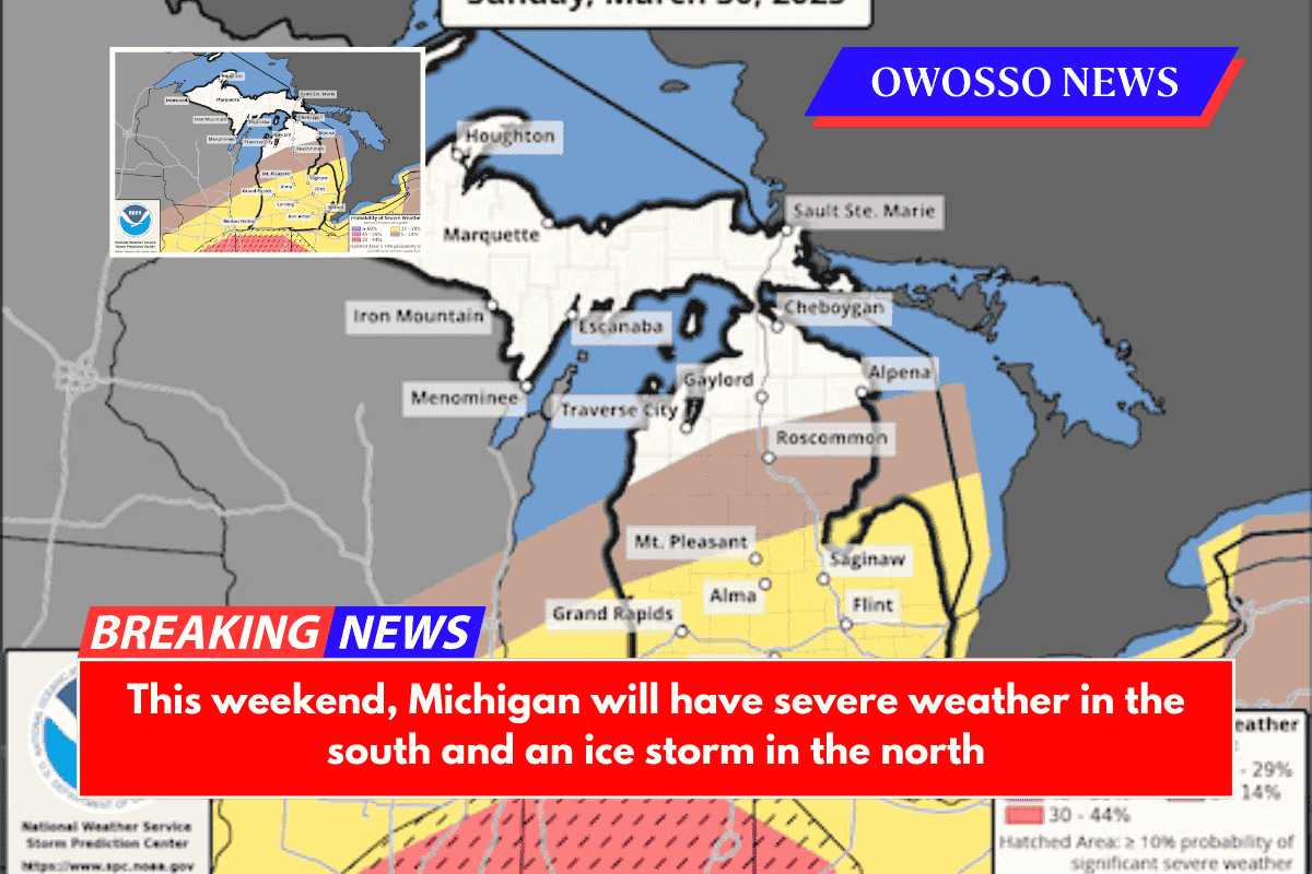
It will be a wild weekend of weather in Michigan.
On Friday, high temperatures will vary greatly across the state, with temperatures in the low 70s near the state border and low 30s in parts of the Upper Peninsula.
This temperature difference is a good indication of the varying weather that the state will experience on the day, as thunderstorms are expected in the southern region of the state and a large ice storm will impact the Upper Peninsula.
Ice Storm
Travel in the Upper Peninsula this weekend will be difficult due to an ice storm that is expected to hit the region. The Gaylord NWS predicts 0.25-0.5 inches of ice accumulation from St. Ignace to Sault Ste. Marie, with potential accumulations as far south as Petoskey and Alpena.
The Michigan Storm Chasers predict travel will be significantly impacted by this system until Saturday.
Fortunately, due to the large temperature gradient, most of the winter weather will remain north for Friday’s system. But that could change on Saturday, as the Gaylord NWS predicts much more ice accumulations in the Northern Lower Peninsula for Saturday night and Sunday.
“The second round of freezing rain is expected to cause more significant icing on Saturday evening and Sunday. This round will benefit much of northern Lower Michigan, particularly east of the US 131 corridor. Hazardous travel, tree damage, and power outages are all possible.”
Severe Weather on Sunday
On Sunday, the risk of severe thunderstorms increases for much of Mid-Michigan and the Thumb Region.
On Sunday, the NOAA Storm Prediction Center forecasted a slight risk of severe storms (2 out of 5) for the lower half of Michigan.
The primary threats for Michigan will be damaging winds and large hail, though the Grand Rapids NWS warns that isolated tornadoes are also possible.
Moving east, the slight risk of severe weather extends through both the Tri-Cities and the Thumb. CBS Meteorologist Ahmad Bajjey mentions the severe weather threat in a Facebook post on Friday morning.
“Severe weather is possible Sunday in the late afternoon and evening,” Bajjey stated in a Facebook post. “A cold front will sweep through the region on Monday morning, giving us a good chance to use up the moisture and heat that has accumulated over the weekend. However, there are still many unanswered questions, particularly about which severe types we might see.”
This is part of a robust severe weather setup across the country, with the Storm Prediction Center issuing an Enhanced Risk for severe storms in nine states along the Mississippi and Ohio River valleys.